Los Angeles to Palmdale Route

Thread started by
robertox at 03.21.12 - 12:41 am
Hi I'm new to the site and I've been searching the internet for a route to Palmdale from Los Angeles Union station to no avail. I used google maps and have mapped a route from Union Staton to Sylmar, but the tricky part is how to get to Santa Clarita then from there to Palmdale. I'd have to get on some highways and that's the part that troubles me.
Just to clarify, CAN I get on the highways as long as i take all safety precautions?
Ex: San Fernando rd or Foothill freeway to get from Sylmar to Santa Clarita and Soledad canyon RD or Sierra Highway to get to Palmdale.
There are some roads better than others i know. but does anybody have any tips?
Id pack everything like emergency repair kit and food as it will be a long distance 8 hour ride..maybe 10 cuz i might be slower than most and will rest...but it seems like a great idea and to be honest im kinda doing it for someone...
NOTE: ive done long rides before, so far my longest is six 6 hours...ill train for it
or is it just a bad idea??
reply
Route i was thinking of taking:
Union station to LA Greenway River Trail
Navigate through Burbank to Glen Oaks Blvd then San Fernando Rd to Sylmar then take either Foothill FWY or San Fernando Rd to Sierra Highway..
then the hard 5 hour trip from Santa Clarita to Palmdale....
either take sierra hwy or Soledad Canyon rd through then use Sierra hwy to get to palmdale..
i've never heard of anyone getting there... so sounds like fun
i guess i should also worry about wind conditions in the mountains?
 robertox
03.21.12 - 12:54 am
reply
Totally doable and an awesome idea. I'm a Newhall native and put in thousands of miles north of Newhall Pass.
So, yeah, you'd make your way to Sierra Highway just south of Newhall pass however you prefer. Sierra Highway will take you all the way to the Palmdale Station, but you have the Soledad Canyon Road option. Soledad and Sierra meet back up in Acton, so it's really of no consequence other than what you prefer to look at en route.
My preference would be Soledad Canyon because it follows the river. You're down in the canyon and often in shadows and trees. There's a rad tunnel, some campgrounds, Shambala Preserve, a cool bridge, and Acton before you meet back up with Sierra Highway to finish the climb up and over into Antelope Valley.
Bonus points for finding Phonehenge West.
 jetfuel
03.21.12 - 8:05 am
reply
NO SHIT....THIS SOUNDS FUN.....ROAD TRIP????
 barleye
 responding to a
comment by Joe Borfo
03.21.12 - 4:08 pm
reply
More like a big bike trip with car support. Not sure I want to ride both to there and back.
Nothing I really can do in the near future though.
 Joe Borfo
 responding to a
comment by barleye
03.21.12 - 4:40 pm
reply
thanks everybody and thanks for the pointers and spots to check out jetfuel!
this is exactly what i was looking for, route ideas and people who've done it before and can give me some ideas of what to expect ahead and their personal preferences.
I think ill be taking the metrolink back honestly. it'll be my longest ride yet.
I've been reading some stuff on fixed gear touring and long distance riding so i might do this on my fixed gear just for the satisfaction of it.
But worried if the climbs are too much for it Ima check the elevations and stuff on google earth, so i might have to use my geared bike.
but from what others have told me its doable on a fixed gear.
i think ill be leaving at 5am or 6 am on a weekend with low traffic maybe a sunday lol
 robertox
 responding to a
comment by jetfuel
03.21.12 - 8:32 pm
reply
More threads like this!
 JOKER
JOKER03.22.12 - 12:46 am
reply
Not to rekindle the dead and beaten geared vs single vs fixed horse, butt....
There is a bunch of elevation change. Much of it is spread out, fortunately. ...but there are some climbs in there.
Sure, mostly anything is ~doable~ fixed. ...but that doesn't mean it's right. There are two climbs on Sierra before Soledad. There are some inclines sprinkled about on Soledad that aren't too bad, but they're more than the average by a bit. You'll be on a constant incline over Vincent Hill.
These bumps won't cause you to dig down into a 42x26 or anything, but who wants to look like some wanker mashing 15-20rpm the whole time.
It's a cool ride though. Crossing into the SCV, you'll be going right by Beale's Cut. If you were to take Sierra all the way instead of Soledad, you'd be passing by the Halfway House - a restaurant that's been there forever marking the half-way point between L.A. and the A.V. Acton's got places to get food and drinks, plus a little market. Past Vincent Hill, you'll pass Pearblossom Highway (an even cooler, but very hilly way to get from L.A. to A.V.), then come out to views of Palmdale reservoir and the Aqueduct (that's got a nice bike path of it's own).
Anyhoo, my pleasure. Totally do the ride. Don't feel bad about railing back home. You did all the climbing and earned the transport back.
 jetfuel
03.22.12 - 7:45 am
reply
...and I just looked at your route. The one you posted takes you out through the middle of Santa Clarita, which is wholly unnecessary. All you gotta do is stay on 'ol Sierra Highway, like this:
http://tinyurl.com/6ouy7sa
 jetfuel
03.22.12 - 7:49 am
reply
Be prepaired for narly headwinds coming from the desert.
 Dedicated818
03.22.12 - 12:56 pm
reply
You can do it no problem. I have a friend in Taiwan (admittedly a monster) who commutes 120 miles to work by bike. It's only one day a week for some seminar, but still, the more you do it, the more of a monster you'll be.
Also, you won't be too far from Metrolink the whole time really.
As for fixed, also not a deal. I know some guys who tour fixed. Make sure you have brakes tho.
LASTLY (tl;dr), if you want a relatively quick and easy elevation profile, do your route in gmaps pedometer, use the
Gmaps to GPX plug in, and then load that data into
GPS Visualizer. Sounds tricky, but I've come to rely on it.
Here's your route:
<script src="//platform.twitter.com/widgets.js" charset="utf-8">
 jeshii
03.23.12 - 2:58 pm
reply
This is a great thread! Anyone have suggestions on where to ride once you're up there? I might be riding over the hill this Thursday, riding around on Friday and then coming back by train.
I was thinking of something like
this route toward the west, or in the other direction, maybe a trip up to the Devil's Punchbowl and back? I don't know where all the interesting stuff is, so any suggestions on where to go (or where not to go), would be helpful. Trying to stay on paved roads, maybe 60-70 miles, or 40-50 miles if there's a lot of climbing.
 nathansnider
03.26.12 - 6:49 pm
reply
The Devil's Punchbowl is nice.
When you get down to the bottom of the trail, you head upstream and can get to a little grotto with a pool of very cold water.
Have been thinking of planning another visit up there myself.
 theroyalacademy
 responding to a
comment by nathansnider
03.28.12 - 12:09 am
reply
You couldn't pick a better route to the west, in my not so humble opinion. Excellent choice. It could be lengthened or shortened, but for the miles you're looking to do, your route gives you the absolute best bang for the buck.
Out east, I'm not as familiar, but if it were me, I'd likely want to head out Fort Tejon Road, through Valyermo, over Wrightwood, then back down to 138 to peck my way back westward.
There's a ride I used to do from Palmdale, up to Wrightwood, Angeles Crest to Angeles Forest, then back to the start point. Lots of climbing, but the area in there between Valyermo and Wrightwood was my favorite portion. Big climb, but gorgeous and quiet. Currently, Angeles Crest is impassable between Wrightwood and Dawson Saddle unless you've got cross country skis or snowshoes.
 jetfuel
 responding to a
comment by nathansnider
03.28.12 - 9:53 am
reply
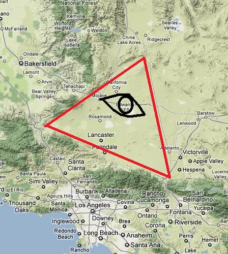
Have you ever noticed from a map or birds eye view that the entire Mojave basin resembles an equilateral triangle and that Edwards Air Force base is in the center of this pyramid? Right above Los Angeles...
Coincidence or CONSPIRACY?
You decide!

 Joe Borfo
 responding to a
comment by nathansnider
03.28.12 - 11:40 am
reply
Thanks for the help and suggestions! I'll report back on whatever we end up checking out in the desert and/or hills.
 nathansnider
03.29.12 - 12:34 am
reply
 -->
-->


